Friday, November 30, 2007

Catal Huyuk and the ‘Semi-Grid’ Pattern

One could safely assume that cities laid out according to a geometric were planned. They were the products of a highly organized society where a ruler or authority can impose a preconceived shape to a new town. That must certainly true for round cities like Gur and Baghdad, and is most probably true of Roman fortresses (Caerleon) and Greek colonies (Miletus). The precise diagrammatic pattern of the settlements strongly suggests central planning.


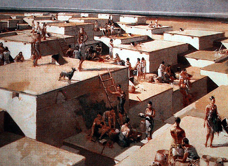
Catal Huyuk , an artist impression from www.anarheologija.org


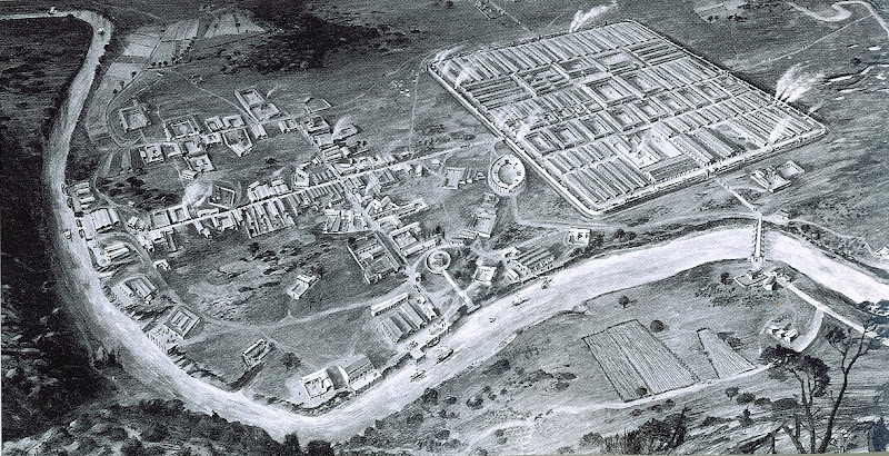
But consider Catal Huyuk in Anatolia in modern Turkey. In this Neolithic village of about 7500 BC, we find individual houses, mainly rectangular in shape, abutting each other to form what is close to a rectilinear pattern.


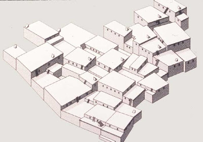
No streets here, just houses next to each other, from www.angelo.edu

There was a tradition of building rectangular buildings. Also there were the actions of individual builders who constructed new houses next to old ones in a pattern that is practical and efficient. No central planning here!


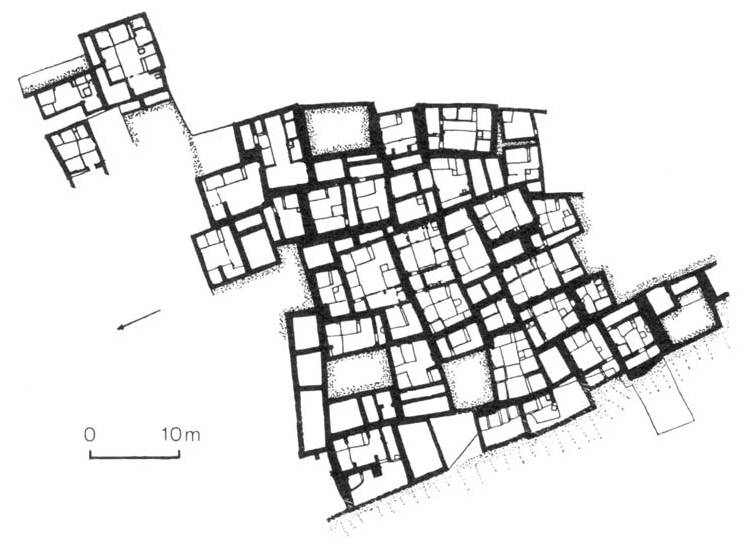
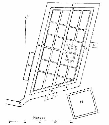
A semi-orthogonal layout, from Michael Smith


References:


Related Post:

Subscribe to Tessellar Blog
and get a FREE E-Book


HONEYCOMB HOUSING
An Affordable Alternative to Terrace Housing


17MB, 49 A4 pages, 57 illustrations


Social Bookmarking

Add to: Digg Add to: Del.icio.us Add to: Reddit Add to: StumbleUpon Add to: Yahoo Add to: Google Add to: Technorati Information

Thursday, November 29, 2007

Roman Fortress

The colonies of Greece, before the Macedonian Age at least, were not conquests. Rather they were new settlements formed by emigration. When the population of an old Greek city grew beyond what the countryside could bear, a group would set out as pioneers to form a new colony or apoike.


From Spiro Kostof, illustration by Alan Sorrell

Not so the Romans. Colonies were outposts of the Rome. The Roman legionary fortress at Caerleon (Wales) was founded about 75 AD. It had a standard headquarters grid plan with two main roads: the via principalis and the via preatoria. At theT-junction of the two streets was the headquarters (principia) and the general’s quarters (praetorium). Barracks lay on the other side of via principalis.

Outside the military camp is the town – a contrast in terms of planning.


References:

  • Spiro Kostof, The City Shaped, 1991

Related Post:

Subscribe to Tessellar Blog
and get a FREE E-Book


HONEYCOMB HOUSING
An Affordable Alternative to Terrace Housing


17MB, 49 A4 pages, 57 illustrations


Social Bookmarking

Add to: Digg Add to: Del.icio.us Add to: Reddit Add to: StumbleUpon Add to: Yahoo Add to: Google Add to: Technorati Information

Tuesday, November 27, 2007

The Terremare in Ancient Italy

The Roman must have learned something about using the grid to lay out cities from Hippodamus and Greeks, but they also had their own gridded settlements. They had the ancient Bronze Age settlements called the terremare from about 1400 and 800 BC.

The people who dwelt in these villages are thought to have come from the north where they lived in lake –villages. But in Italy, on the the highlands, they created artificial island- villages surrounded with a water-filled moat.


“At Castellazzo di Fontanellato, a little west of Parma, are the vestiges of a settlement which, with its defences, covered an area of about forty-three acres. In outline it was four-sided; its east and west sides were parallel to one another. Round it ran a solid earthen rampart, 50’ (15m) broad at the base and strengthened with woodwork . In front of the rampart was a wet ditch (A), 100’ wide, fed with fresh water from a neighbouring brook by an inlet at the south-western corner (C) and emptied by an outfall on the east (D). One wooden bridge gave access to this artificial island at its southern end (E)".


"The area within the rampart, a little less than thirty acres in extent, was divided into four parts by two main streets, which would have intersected at right angles had the place been strictly rectangular; other narrower streets ran parallel to these main thoroughfares. On the east side (F) was a small 'citadel'—arx or templum—with ditch, rampart and bridge of its own (G, H); in this were a trench and some pits (K) which seemed by their contents to be connected with ritual and religion. Outside the whole (L, M) were two cemeteries, platforms of urns set curiously like the village itself, and also a little burning ghat. The population of the village is reckoned to be four or five thousand, crowded into small huts”.


References:

  • Spiro Kostof, The City Shaped, 1991
  • F. Haverfield, Ancient Town-Planning, 1913, download from Project Gutenberg

Related Post:

Subscribe to Tessellar Blog
and get a FREE E-Book
HONEYCOMB HOUSING
An Affordable Alternative to Terrace Housing


17MB, 49 A4 pages, 57 illustrations


Social Bookmarking
Add to: Digg Add to: Del.icio.us Add to: Reddit Add to: StumbleUpon Add to: Yahoo Add to: Google Add to: Technorati Information

Sunday, November 25, 2007

Circleville, Ohio

From rootsweb.com


From top to bottom, Circleville in 1811, 1837, 1838, 1849, and 1856

Daniel Driesback laid out this circular town with radiating avenues in 1810. It was based on a circular mound that had been built by Indians before the city was built. In the centre plaza, on top of the mound, was an octagonal courthouse. Outside the circle though was a grid.

But he grid eventually overtook the circular centre.
By the time James Silk Buckingham visited the site in 1840, he wrote:
“So little veneration …have the Americans for ancient remains…that this interesting spot of Circleville, is soon likely to lose all traces of its original peculiarities. The circular streets are fast giving way, to make room for straight ones; and the central edifice itself is already destined to be removed, to give place to stores and dwellings; so that in century or less, there will be no vestige left of that peculiarity which gave the place its name, and which constituted the most perfect and therefore the most interesting work in antiquity of its class in the century”

In fact it took only about 50 years.


References:

  • Spiro Kostof, The City Shaped, 1991
  • Quote from J.S. Buckingham, “The Eastern and Western states of America”, 1842, quoted in Spiro Kostof, The City Shaped, 1991, pp 162

Related Posts:

Subscribe to Tessellar Blog
and get a FREE E-Book
HONEYCOMB HOUSING
An Affordable Alternative to Terrace Housing


17MB, 49 A4 pages, 57 illustrations


Social Bookmarking

Add to: Digg Add to: Del.icio.us Add to: Reddit Add to: StumbleUpon Add to: Yahoo Add to: Google Add to: Technorati Information

Saturday, November 24, 2007

The Hexagonal Plan for Detroit

Thomas Jefferson appointed Augustus Woodward on March 3, 1805 as the Michigan Territory's first Chief Justice. The judge arrived with the city in ruins from a devastating fire.

“Speramus meliora; resurget cineribus” - we hope for better things; it will arise from the ashes - became the city's motto. Woodward, turned town-planner, came up with a hexagonal plan with a park in the middle and wide streets radiating outward in a triangular pattern:


“ the bases of the town …shall be an equilateral triangle,having each side of the length of forur thousand feet (1200 meters), and having every angle bisected by a perpendicular line upon the opposite side”.


Woodward’s hexagonal grid plan for Detroit, 1807.
Source:Cauchon (1927)


From en.wikipedia.org

Citizens who had lost their homes were given larger pieces of land. The idea was that additional hexagons could be added one as the city grows. But this plan was abandoned after just 11 years, and a grid street pattern was superimposed over the hexagonal design.


References:

  • Spiro Kostof, The City Shaped, 1991
  • Eran Ben-Joseph and David Gordon,Hexagonal Planning in Theory and Practice, Journal of Urban Design, Vol. 5, No. 3, 2000
    2 Mb pdf download

Related Posts:

Subscribe to Tessellar Blog
and get a FREE E-Book
HONEYCOMB HOUSING
An Affordable Alternative to Terrace Housing


17MB, 49 A4 pages, 57 illustrations


Social Bookmarking
Add to: Digg Add to: Del.icio.us Add to: Reddit Add to: StumbleUpon Add to: Yahoo Add to: Google Add to: Technorati Information

Friday, November 23, 2007

Celtic Round House


From www.shee-eire.com

I studied architecture in Wales, but I did not find out about Celtic round houses until quite recently. These date from the iron-age about 800 BC to the arrival of the Romans about 45 AD.

Archaeological remains of an round house can be found on the flat top of a low ridge on Moel y Gerddi hill in Llanfair in Wales.

The house is in the centre of a circular enclosure approximately 30 meters across. The house is 10 meters in diameter, with two doorways, facing east and west. There is an inner ring of 12 post holes approximately 1.5 meters in from the wall. In the centre of the house is a fireplace of flat stone slabs, in a shallow depression, covering an area of about 1 square meter.


Interior layout of the round house

The walls of the houses were made of wattle and daub. The wattle walls were made from weaving a fence of hazel or willow sticks. The daub was made of a mixture of clay, straw and animal dung! The straw and dung help to stop the clay from cracking and falling away. The walls were lime-washed to create a better appearance and make the houses a little brighter.


The timber roof frame sitting on the wattle wall

Fast forwad to 2002: a replica was constructed at Butser Ancient farm, in Hampshire, England.


The thatch goes up


The completed roof from inside, before
it gets blackened by soot from the hearth


Daubing the wattle wall


The walls lime-washed and the house completed

This is a very good interactive animation from the BBC.


From www.bbc.co


References:

Reference and Photos, from
Subscribe to Tessellar Blog
and get a FREE E-Book
HONEYCOMB HOUSING
An Affordable Alternative to Terrace Housing


17MB, 49 A4 pages, 57 illustrations


Social Bookmarking
http://www.bbc.co.uk/history/interactive/animations/ironage_roundhouse/index.shtml Add to: Digg Add to: Del.icio.us Add to: Reddit Add to: StumbleUpon Add to: Yahoo Add to: Google Add to: Technorati Information

Wednesday, November 21, 2007

The Batak Karo

There are six distinct Batak tribes: of these the Karo have resisted change and retained their traditions more than the others. Most Karo today practice either Christianity or Islam - many of them alongside their traditional beliefs.


The Batak Karo house with its hipped roof is distinct from that of the other tribes . Up to twelve families might live in one of these houses, although eight is the norm. They are built from natural materials - mainly wood and bamboo - using no nails, spikes or screws, but simply held together with fiber from ijuk palm, which is also the principle source of their thatched roof.


There are five clans in the Karo Batak community. Their traditional law, called adat or bicara, spells out what kinds of conduct one must follow, particularly obligations to their clan.For example, the adat does not allow two people of the same clan to marry - even if there is no traceable blood relation between them. This taboo is strictly enforced to this day. When a woman is married, she transfers into the clan of her husband, which instantly gains her many new relatives.


Spirits figure prominently in the traditional world of the Karo. They believe the soul has two parts: the life force, which can leave a person's body and enter another person's or an animal's body, and the spirit (begu), which, upon death, is all that remains of a person. The begu must be exalted to become one with the "essential spirit". So, although they bury their dead, the Karo later exhume the bones of especially important ancestors and carefully wash them before decorating them in silver and gold, then displaying them in skull houses (geriten) made especially for the purpose.


Rituals involving contact with the spirit world are led by a male guru who is trained in the techniques of magic, while a female spirit medium may be also present, and through whom the spirits communicate their wishes to the living. Some of these spirits are also non-human - those of the land, the mountains and the harvest. Spirits of dead ancestors are especially important. A man's immediate ancestors are believed to guard his household.


References:

Related Posts:


Subscribe to Tessellar Blog
and get a FREE E-Book
HONEYCOMB HOUSING
An Affordable Alternative to Terrace Housing


17MB, 49 A4 pages, 57 illustrations

Tuesday, November 20, 2007

The Batak House in Sumatra


A Batak village, from Dwellings, Paul Oliver, 2003

The Bataks of North Sumatra were said to have practised ritual cannibalism. Marco Polo wrote in 13th century that inhabitants of that island ate their parents when they became too old for work; Raffles in the 19th century stated that for certain crimes a criminal would be eaten alive. According to a New York Times article, the eating of human flesh was always a highly formalized ritual, and the diners were picky - only outsiders, consenting old people and certain kinds of criminals were consumed.

Now the Bataks are mainly Christian: they were converted over a century ago.

“However, Batak Christianity can sometimes seem little more than nominal. You may, for instance, see the pastor beating on a drum for two days to ward off devils, or a church wedding followed by the traditional unjung ceremony, which unites clans by a ritual slaughtering of a water buffalo and a protracted communal bartering over a bride-price. The family and kin group remain the basic Batak social institutions and many aspects of their complex, pre- Christian forms of ancestor worship are still practiced”.


A Batak house, from www.travbuddy.com


The traditional, or adat-style, Batak houses can be large: up to 60 feet long and housing up to 12 families . They have distinctive saddle-backed, twin-peaked roof – like the horns of a buffalo - made from a special palm fibre and commonly anchored by long poles. But now they tend to be made from corrugated steel.


The front of the house, but where is the door? From www.travbuddy.com

Traditionally, Batak houses have no doors, but are entered by a ladder through a trapdoor in the raised floor. Inside it is dark because there are no windows!


Interior, from www.pbase.com

In some villages the houses are often built in two rows, the rumah or house facing south opposite the sopo facing north. In between is the halaman or plaza from where the grand houses can be admired.


References:


Related Posts:


Subscribe to Tessellar Blog
and get a FREE E-Book
HONEYCOMB HOUSING
An Affordable Alternative to Terrace Housing


17MB, 49 A4 pages, 57 illustrations

Robert’s Quadruple Houses

Sorry, if you see
an ad banner here,
it was planted by
a virus.
I'm still trying
to get rid of it!


I was happy to find out that I’m not the only one who has been plugging Quadruple Houses on the internet. I discovered Robert via the comments to one of my posts - he gave me the link to his website.

You can find his ideas for cross-plan quadruple houses. Robert sees them as a suitable type of house for new-urbanist neighbourhoods.


Four quadruple houses, equivalent to four detached houses, are linked to form a cruciform block.

Instead of rows of detached single family homes which have skinny yards around the house which are hardly useable, the cross-form quadruple houses place all the green area in the front garden.


Based in Alabama, he discovered the quadruple house through Frank Lloyd Wright.

This is a walk along the main road:


So Robert, welcome to the club!

References:


Subscribe to Tessellar Blog
and get a FREE E-Book
HONEYCOMB HOUSING
An Affordable Alternative to Terrace Housing


17MB, 49 A4 pages, 57 illustrations

Saturday, November 17, 2007

Walls made Simple.

Sorry, if you see
an ad banner here,
it was planted by
a virus.
I'm still trying
to get
rid of it!


In Malaysia buildings are most commonly built with a reinforced concrete floors, columns and beams, together with bricks walls. It is a flexible method suitable for single storey buildings as well as high-rise. However, it requires temporary timber to be used as formwork which acts as a mold for the wet concrete. And it needs quite a large amount of steel.

For low-rise buildings the old fashion concrete blocks can also be used – this building method does not need formwork and uses less steel. But in Malaysia, the problem is that there is a lack of block-laying skill. In practice it doesn’t turn out to be cheaper because more has to be spent on the labour to put up the block wall. This is true even in the situation where the average semi-skilled worker on site (usually from neighbouring Indonesia) only earns about RM 70 a day (USD 20).

The humble concrete block has been around for a long time, but it is still capable of being improved. Another speaker at Peter Davis’s seminar last month was Chou Kan Yin who presented his interlocking blocks.

It’s a simple idea. The blocks have tongue and groove edges – so that they interlock like ‘lego’ blocks. Laying these blocks is easy and doing it properly results in perfectly straight walls which need minimal plastering (another cost saving).

Picasa SlideshowPicasa Web AlbumsFullscreen


About 70% less steel bars is used.

Picasa SlideshowPicasa Web AlbumsFullscreen


A few years ago, Chou completed a couple of blocks of 4 storey apartments and several two storey detached and semi-detached house s that I designed.

Picasa SlideshowPicasa Web AlbumsFullscreen


I was very impressed by the quality of his work. As the cost of building materials continue to rise, and as long as cheap labour is still available, the economic advantages of his interlocking blocks will become more compelling.


References:


Hydraform is about interlocking clay-cement bricks from South Africa.

Related Posts:

Subscribe to Tessellar Blog
and get a FREE E-Book
HONEYCOMB HOUSING
An Affordable Alternative to Terrace Housing


52 MB, 49 A4 pages, 57 illustrations


Social Bookmarking

Add to: Digg Add to: Del.icio.us Add to: Reddit Add to: StumbleUpon Add to: Yahoo Add to: Google Add to: Technorati Information

Wednesday, November 14, 2007

The Round City of Baghdad #2


Plan

The Round City of Baghdad was also called Madinat-As-Salam: the City of Peace.

A round city wall was both cheaper to build for a given area and easier to defend. To improve the defenses were bent entrances and the double wall.


Artist's Impression

But the circular arrangement of streets and gates was also also tonreflect the orbit of planets,and the central position of the palace and mosque reflects the sun as the center of universe.

As it turned out, the history of Baghdad did not turn out to be so peaceful.


Islamic understanding of the shape of the earth

From 836 to 892 the capital was transferred to Samarra because of troubles with the caliph's Turkish troops in Baghdad. When Caliph al-Mu'tamid moved back to Baghdad he settled on the east bank of the Tigris which has remained the centre of the city to the present day.

In 1258 Hulagu Khan, a grandson of Genghis Khan captured, sacked, and burned Baghdad.


The Grand Library of Baghdad was destroyed. The Tigris ran black with ink from the enormous quantities of books flung into the river.


Hulagu’s Mongol army at Baghdad from wikimedia

The Mongols looted and then burnt mosques, palaces, libraries, and hospitals to the ground.

Estimates of people massacred range from 90,000 to 200,000. Hulagu had to move his camp upwind of the city, due to the stench of decay from the ruined city.

The Mongols rolled the caliph up in a rug, and rode their horses over him.

The destruction of Baghdad was to some extent a military tactic: it was supposed to convince other cities and rulers to surrender without a fight. But failed in Egypt, which defeated the Mongols at the Battle of Ain Jalut in 1260.


References:


Related Posts:

Subscribe to Tessellar Blog
and get a FREE E-Book
HONEYCOMB HOUSING
An Affordable Alternative to Terrace Housing


52 MB, 49 A4 pages, 57 illustrations


Social Bookmarking


Add to: Digg Add to: Del.icio.us Add to: Reddit Add to: StumbleUpon Add to: Yahoo Add to: Google Add to: Technorati Information

Tuesday, November 13, 2007

Post no. 100 !

Thanks to my readers, I've made it this far.

And I'm looking forward to the next 100!

To celebrate, I'm releasing a free E-book "Honeycomb Housing" for subscribers: just look for the download link at the bottom of the post emailed to you.

If you have not subscriber, click here to get the Free E-book immediately.

FREE E-BOOK


HONEYCOMB HOUSING
An Affordable Alternative to Terrace Housing

52 MB, 49 A4 pages, 57 illustrations

REVIEW
“.......Honeycomb Housing by Mazlin Ghazali is dedicated to a design solution revolving around the availability of suitable land, the high cost of such land and the cost of a single family dwelling. Planners have long searched for solutions given these parameters. Malaysia has a burgeoning population and a finite amount of suitable building sites. The solution has been the unsuitable terrace house with all its inherent problems. Mazlin Ghazali has arrived at what seems to be an eminently suitable solution—i.e., the honeycomb plan. In this design he has tackled the parameters with élan.

Less space is dedicated to suitable high-density housing, if such a thing exists at all. Also, as applicable as the honeycomb solution appears to be, one wonders if it is appropriate to the varied topography of much of Malaysia. In Malaysia, the wanton destruction of forests is seconded by the pulling down, terracing or levelling of hills and ridges".

FEDRICK W. BUNCE, M.F.A.,PhD., PROFESSOR EMERITUS OF ART, INDIANA STATE UNIVERSITY, USA


Social Bookmarking
Add to: Digg Add to: Del.icio.us Add to: Reddit Add to: StumbleUpon Add to: Yahoo Add to: Google Add to: Technorati Information

Sunday, November 11, 2007

The Round City of Baghdad

In 754, al-Mansur became the second Abbasid Caliph who commissioned the construction of a new capital - Baghdad.

During al-Mansur's reign there was a rapprochement between that Persians and Arabs. Persian literature and scholarship became appreciated in the Islamic world.

Photo Sharing and Video Hosting at Photobucket
Plan of the Round City of Baghdad, from www.faculty.fairfield.edu

Baghdad’s round plan found Persian precedents such as Ectabana, Hatra and Firouzabad. According to Manouchehr Saadat Noury (Persian Journal, 2005) two designers who were hired by Mansur to plan the city's design were two Iranians named Naubakht-e-Parsi, a former Persian Zoroastrian, and Mashallah-e-Assiri, a former Jew from Khorassan (a northeastern province in present-day Iran).

The city was designed with ash drawings onto the ground for al-Mansur to view prior to construction, which began that same year. By its completion in 766-7, it has been posited that the Round City measured 2000 meters in diameter.

It featured four main gates, equidistant from each other: the southwest gate was the Kufa Gate; the southeast was Basra; the Khurasan Gate extended to the northeast and the Damascus Gate to the northwest. The walls were constructed out of mud brick with reed supports, while the domes and vaults were composed in baked brick.

References: www.faculty.fairfield.edu,
Manouchehr Saadat Noury


Related Post:


Enter your Email


Preview | Powered by FeedBlitz

Subscribe in a reader


Social Bookmarking

Add to: Digg Add to: Del.icio.us Add to: Reddit Add to: StumbleUpon Add to: Yahoo Add to: Google Add to: Technorati Information

Saturday, November 10, 2007

Actually Useful Minimalism

I'm not a fan of architectural minimalism. To me its modern architecture stripped of it's original social idealism. Minimalism is just another "style" which always turns out to be deceptively expensive.

Late last month, my friend Peter Davis held a seminar at his home. One of his guest speakers was another long-time colleague, Yogen, who showed his work as an agricultural contractor. Among other things, he builds really cheap animal housing using minimal structure.


Biologically secure closed housing for poultry, installed with cooling system


And Yogen has also developed and implemented a very cost effective cooling system for the buildings.

Now this, in my opinion, is what minimalism should be about:

Picasa SlideshowPicasa Web AlbumsFullscreen


Contrast this with this "Agro-Housing" proposal for Wuhan in China. Here housing and high-tech farming is fit together in a high-rise structure. No way is this going to be economically feasible.


Agro-Housing, from architecture.myninjaplease.com

Tack on the buzz-word "sustainable", and that seems enough to justify the craziest sorts of ideas.


Related Post:


Enter your Email


Preview | Powered by FeedBlitz

Subscribe in a reader


Social Bookmarking

Add to: Digg Add to: Del.icio.us Add to: Reddit Add to: StumbleUpon Add to: Yahoo Add to: Google Add to: Technorati Information

Thursday, November 8, 2007

Hillside Honeycomb Layout

A common question I get is whether the tessellation layout is suitable for sloping sites. I had a go at trying to answer this on my FAQ’s page, but perhaps the answer there was a bit too theoretical.

My office just prepared a tessellation housing layout on a sloping piece of land – it's our first opportunity to flesh out some of the details on a real site.


There is about a 13m (43’) difference in level between the highest and lowest points on the site. Maximum slope on the roads is 1:10, and the highest retaining wall is 4.5m (15’).


More later.


Related Post:


Enter your Email


Preview | Powered by FeedBlitz

Subscribe in a reader


Social Bookmarking

Add to: Digg Add to: Del.icio.us Add to: Reddit Add to: StumbleUpon Add to: Yahoo Add to: Google Add to: Technorati Information

Tuesday, November 6, 2007

Children in the City – Five Oaks

In the Five Oaks community of Dayton, Ohio, during 1991, violent crimes increased by 77 percent, robberies by 77 percent, vandalism by 38 percent, and overall crime by 16 percent. Drug dealers, pimps, and prostitutes had taken over the streets with abandon. Gun shots could be heard at all times of the day and night; racing cars and blaring boom-boxes disturbed everyone's sleep. Children stayed locked up in their homes.


Plan of original layout of Five Oaks

Five Oaks consisted of about 2,000 households with different types of one- and two-family row housing in a rectilinear grid layout near the downtown area of Dayton, Ohio.

The City of Dayton asked Oscar Newman to apply the "Defensible Space" concept to the Five Oaks neighbourhood. Working with the community and city staff, he reorganized Five Oaks into 10 mini neighbourhoods: cul-de-sac streets with gates to block the heavy through-traffic that had plagued the area.

The changes were to accomplish a few important things: remove vehicular through-traffic completely; completely change the character of the streets (instead of being long, directional avenues laden with traffic, become places where children could safely play and neighbours interact); define the mini-neighbourhood streets as being under the control of the residents, and fewer cars would mean easier recognition of neighbours – and strangers. Access to the newly-defined mini-neighbourhoods, composed of from three to six streets, would be limited to one entry portal off an arterial street.


Portal as designed


Portal as built


Limiting access and egress to one opening would mean that criminals and their clients would have to enter a small mini-neighbourhood to transact their business, and they would have to leave it the same way they came in. There would no longer be a multitude of escape routes. A call to the police by residents would mean that criminals would meet police on their way out. It was reasoned that such a street system would be perceived by criminals as too risky.


Gates defined the neighbourhood boundary

The subdivision of a community into mini-neighbourhoods was intended to encourage the interaction of neighbours. Parents watch their children playing in the now quiet streets and get to know each other. They no longer feel locked in their houses, facing the world alone.

Community Participation in Designing Mini-Neighbourhoods


As many people as possible were invited to participate in defining the boundaries of their mini-neighbourhoods, that is, in deciding which streets should remain open and where the gates should go up. At a community meeting to plan the mini-neighbourhoods in Five Oaks, residents took turns marking on a map what they thought of as their mini-neighbourhoods, according to the following principles:

  • Smallness is essential to identity, so a mini-neighbourhood should consist of a grouping of no more than three to six streets. The optimal configuration for a mini-neighbourhood is a Greek cross, a vertical with two horizontals. Only one point of the cross will remain open, the other five will have gates across them.


  • Mini-neighbourhood

  • Cul-de-sac configurations should not be too large, for they take residents too far out of their way and produce too much of their own internal traffic.

  • A mini-neighbourhood should consist of a grouping of streets sharing similar housing characteristics: building type (such as detached, semi-detached, row houses, and walk-ups), building size, lot size, setbacks from the street, building materials, architectural style and density.

  • To facilitate access by emergency vehicles, access to the entry portal of each mini-neighbourhood should be from existing arterial streets. As much as possible, these arterials should be on the border of the Five Oaks community to enable outsiders to find their way in easily.


  • Mini neighbourhoods

  • Mini-neighbourhoods and their access arterials should be designed to facilitate access but discourage through-traffic.


Layout Plan of Five oaks after change

Altogether, 35 streets and 25 alleys were closed in Five Oaks. The major arterials that defined the periphery of the community were retained intact and allowed east-west and north-south movement past the community.

Results: Reduction in Crime


Within the next two years, overall crime fell by 25 percent and violent crime by 50 percent, according to the city's Office of Management and Budget. Traffic was reduced by 67 percent, and traffic accidents by 40 percent. Robbery, burglary, assault, and auto theft were found to be the lowest in five years, while crime had increased 1 percent in Dayton overall. Individual families' investment in their homes had substantially increased, and for the first time in many years, houses in the neighbourhood were attracting families with children.

Increase in the Value of Homes

Along with reductions in crime, housing sales increased by 55 percent and housing values increased by 15 percent, compared to 4 percent in the region.


People started upgrading their houses

Peopled Felt Safer

In addition to the data collected by the city, a survey of residents by the University of Dayton before the changes and afterwards found that 53 percent thought there was less crime, and 61 percent thought the neighbourhood was a better place to live in. Drug-dealing, theft from houses and cars, and harassment were each found to be less of a problem than it had been a year previously. Most importantly, there was no difference in the perception of change between whites and blacks or between renters and homeowners.

Crime did not just move elsewhere


The usual complaint about such programs, that they displace crime into the surrounding neighbourhoods, proved untrue. Crime in the surrounding communities decreased 1.2 percent. The police explain this saying that the perception among criminals is that the residents of Five Oaks have taken control of their streets, and because the criminals and their clients don't know the neighbourhood's exact boundaries, they have moved out of the surrounding area as well. The positive effects of the Five Oaks section spilled over into the bordering communities – some of whom are now adopting a similar restructuring.

Cost Effectiveness

The entire cost of this project was USD693,375 – approximately USD10,000 per street. In effect, the increase in value of just one home in one year, on a street of 30 homes, paid for the cost of that street closure.

Sense of community


Five Oaks demonstrated that once people come together within their own mini-neighbourhood, they reach out to other neighbourhoods and to the larger urban community. In other cities, mini-neighbourhood plans have not only arrested decline; they have made people realize they could be effective in intervening to change things. It has also led them to become active in city politics.

Children played on the streets.


Excerpted from Oscar Newman, “Defensible Space”, Shelteronline

Related Post:


Enter your Email


Preview | Powered by FeedBlitz

Subscribe in a reader


Social Bookmarking

Add to: Digg Add to: Del.icio.us Add to: Reddit Add to: StumbleUpon Add to: Yahoo Add to: Google Add to: Technorati Information

Monday, November 5, 2007

Toraja

"There is a belief in Toraja that when you die you won't be separated directly from the family - you are expected to bring them good luck and so the family must respect you. When we think of our ancestors, we respect them as individuals, rather than as a group".

"When a small baby dies, one who hasn't grown teeth yet, they used to be buried in a tree. It had to be a living tree, so that as the tree grew it continued the baby's life".

Nicolaus Pasassung, Sa'dan, Rantepao, Toraja

The Toraja live in stunningly beautiful houses in the mountainous southern region of the Indonesian island of Sulawesi. Their houses look like boats redesigned to sit on land.

Although mainly of Christian faith, many elements of the traditional religion, aluk to dolo ('the law of the ancestors') are still followed, especially in rural areas.


from Toraja Photo Gallery

In particular, they have unique death rituals.

“Spirits of the dead can be harmful or protective depending on how they died. People who died an unnatural death, such as through suicide, accidents or in childbirth, will not go easily to puya, the land of the dead. Ancestors must be treated with appropriate esteem or they will become unhappy, impoverished spirits”.

“The most important ceremony in a person's life cycle is the funeral. For this reason, there is often a lengthy interval between a person's death and their burial. Time is needed to ensure that all family members can attend and to save money to buy buffalo. In some cases, the deceased may be kept in the house for years, injected with formalin and placed in a temporary wooden coffin. In the past, the body would be laid on a mat in a special room, with bamboo pipes under the floor to catch and divert body fluids”.


Row of funeral houses on the rante, Toraja region, from Australian Museum Online

“Death is a gradual process rather than an abrupt event. The deceased is referred to as to mamma (sleeping person) or to masaki (sick person) until the commencement of funeral rites when they are called to membali puang (person who has become one of the gods) or to mate (dead person)”.

“The funeral is conducted on the rante (funeral ground) on which temporary structures are built to house the mourners and corpse”.


Tau tau gallery at the entrance of a burial site, near Rantepao, from Australian Museum Online

“Wooden human figures called
tau tau
accompany the deceased on their journey from the funeral house to the burial ground, where they watch over both the living and the dead. Once carved only for wealthy families, they are now status symbols used by a range of families”.

“Prior to the 17th century, Torajans were buried in elaborate, boat-shaped wooden coffins stored at the base of cliffs. After heirlooms were extensively plundered, Torajans began burying their dead in high cliff-face vaults. It is now common for people to be buried in family vaults”.


Toraja burial site near Londa, South Sulawesi, from Australian Museum Archives


Related Post:


Enter your Email


Preview | Powered by FeedBlitz

Subscribe in a reader


Social Bookmarking
Add to: Digg Add to: Del.icio.us Add to: Reddit Add to: StumbleUpon Add to: Yahoo Add to: Google Add to: Technorati Information

Sunday, November 4, 2007

Circular Cities in Ancient History

Herodotus described Ectabana (founded in 715 BC, now Hamadan in Iran) as the capital of Medes on a gentle hill in a plain in northwest Iran and became the summer residence of the Achaemenid Persians. Herodotus described the city as being ringed with seven concentric walls. Each was painted with a different colour to identify it with one of the planets, beginning with white (Jupiter) on the outer wall and ending in the middle with silver for the moon and gold for the sun. The king and his court were in the centre, lesser officials stayed in the outer rings in order of rank; common folk lived outside.

Hatra was surrounded by two round walls, and had a large temple complex in the center. Another Parthian city Darabjerd in southern Iran, had two rock formations within its perfectly circular wall: one a castle, the other a temple.

Modern Firuzabad, known as Gor and Ardashir-Khorra (“Glory of Ardashir”) in Sasaian times, is said to have been founded by Ardashir I (AD 224-241), Gor was Ardashir’s stronghold in his revolt against the last Parthian king. The Sasanian town was a round city encircled by double walls separated by a 35 m wide ditch pierced by four axial city gates. The plan of the town was a perfect circle, 1,950 m in diameter, divided precisely into twenty sectors with radial concentric streets.


Arial photo of ruins, from Berghe, Louis Vanden


Fire Temple, from, Cultural Heritage of Fars

“A walled central inner city probably housed official buildings at the center of which stood Ardashir’s fire temple, represented by stone building known as Takht-e Neshin.”

“The building was a long rectangular structure divided into a reception area backed by residential quarters. A long entrance hall, or ayvan, led into a high domed room, the principal audience chamber which was flanked by other domed rooms that occupied a 14m wide area on the north side of the palace. To the south, a smaller ayvan led to an inner courtyard backed by a second axial ayvan. The barrel-vaulted rooms that surrounded the courtyard constitute the residential part of the complex.”


Adashir’s Palace from Herrmann, Georgina

“Ardashir’s palace is a monumental structure of rough stone and gypsum mortar, built without fortifications, after his accession. Rectangular halls in the palace were roofed with domes constructed of rubble and gypsum mortar. This exceptionally strong and resilient dome rested on a transitional zone that transformed the rectangular walls of the room into a circular base for the cupola through the use of a small arch, the squinch, built above the four corners of the walls. This modest invention was eventually elaborated, and magnificently embellished with colored mosaics and tiles, in the later domes of Islamic Iran.”


References: Spiro Kostof, The City Shaped, 1991,
Excerpts from The Near East in Late Antiquity: The Sasanian Empire, University of California, Berkeley


Related Post:


Enter your Email


Preview | Powered by FeedBlitz

Subscribe in a reader


Social Bookmarking

Add to: Digg Add to: Del.icio.us Add to: Reddit Add to: StumbleUpon Add to: Yahoo Add to: Google Add to: Technorati Information

Friday, November 2, 2007

GREEK TOWN-PLANNING: THE MACEDONIAN AGE

After Alexander the Great conquered Western Asia in the 4th century BC, he and his successors founded new cities. Discharged soldiers become their first citizens. Many of these were laid out with a regular 'chess-board' street-plan.

Alexander himself and his architect, one Dinocrates of Rhodes or perhaps of Macedonia, seem to have employed it at Alexandria in Egypt. Antioch, its port, Seleucia Priera, Apamea and Laodicea – all founded by Seleuceus I – have blocks of the same size (112m x 58m). The grid plan, history shows, is much liked by military colonizers.

An example is Priene, a little town on the east coast of the Aegean. Early in the Macedonian age it was re-founded. It had about 400 individual dwelling-houses and a population of about 4,000.

It provides an interesting case of the grid applied to a steeply sloping site. But it is a rather functional arrangement: no striking artistic effects appear to have been attempted. No streets give vistas of stately buildings. No squares, other than the Agora, provide open spaces where larger buildings might be grouped and properly seen. Open spaces were very rare in Priene. Gardens, seem entirely absent.


PLAN OUTLINE OF PRIENE
A, B, C. Gates. D, E, F, H, M, P. Temples (see fig. 7). G. Agora, Market. I. Council House, K. Prytaneion. L, Q. Gymnasium. N. Theatre, O. Water-reservoir, R. Race-course, from Haverfield


Perspective view, from Haverfield

But the Greek grid was alien to many of the local cultures conquered by Alexander. Many reverted to original ways – buildings encroached into the wide streets, and open space were taken over by small shops and stalls, and the grid would lose its form.

References: Spiro Kostof, The City Shaped, 1991.
F. Haverfield, Ancient Town-Planning, 1913, download from Project Gutenberg


Related Post:


Enter your Email


Preview | Powered by FeedBlitz

Subscribe in a reader


Social Bookmarking
Add to: Digg Add to: Del.icio.us Add to: Reddit Add to: StumbleUpon Add to: Yahoo Add to: Google Add to: Technorati Information

Thursday, November 1, 2007

Quarter-detached houses in Maran

The cluster house (Charles Bage, England), le carre mulhouse (Muller, France), the quadruple house (Frank Lloyd Wright, US) – different names for a type of house that did not quite catch on anywhere in the world…….except perhaps in Malaysia. It is not that this house-type is common, but developers here have been building cluster houses since the 1970’s.
Initially, they were low-cost houses, but lately they have tended to be priced in a more expensive category – cheaper than semi-detached houses, but more expensive than terrace houses.

In Maran, a district town in the state of Pahang in Malaysia, I have designed a cul-de-sac neighbourhood right next to the town-centre.


Mosaic cul-de-sac


In this layout are “quarter-detached houses” - the same concept with yet another name (sorry).


Quarter-detached houses


Then there are the “corner quarter detached houses”, a close relative of Frank Lloyd Wright’s quadruple house: viewed from any one driveway, you see a unit that looks like a detached house!


corner quarter-detached house


There are also “garden townhouses”, much like the quarter-detached houses, but with separate units upstairs and downstairs; and with each unit having its own garden and private car porch.


Downstairs unit, with a garden at the side


Upstairs unit with a garden and porch below


There is a variant of the garden townhouse when it is located at the corner of two streets.


16Mb,60 seconds

More about this project later.


Related Post:


Enter your Email


Preview | Powered by FeedBlitz

Subscribe in a reader


Social Bookmarking


Add to: Digg Add to: Del.icio.us Add to: Reddit Add to: StumbleUpon Add to: Yahoo Add to: Google Add to: Technorati Information