Sunday, December 30, 2007

The Round Tents of Central Asia


From www.manas.afnews

From the Caspian Sea to Mongolia, Turkomen, Kazakhs, Uzbeks, Kyrgyz, and Mongolians live in tent dwellings – with single-room circular plan, lattice frame of willow wands that expand to form the wall but which retract to a compact shape, and light poles arc to form the roof structure joining a ring at the crown. Once the structure is up, the structure is covered with woollen felt mats.


From Paul Oliver

The Kyrgyz yurta has the entrance facing south. Inside, one is supposed to move in a clockwise direction . The interior is divided into four sections: one enters at the entrance in the southern quadrant; move left though the male domain with saddles, weapons and hunting gear; then through the north quadrant, where the altar sits facing the entrance and where important guests are received. The quadrant comes next is where women and children sleep.


From Paul Oliver

At the centre, directly below the ring crown/smoke hole, is the hearth.

The spatial organization in the yurta is not only functional but has assumed the trappings of a tradition. Nowadays, most Kyrgyz live in apartments, but they still put up the yurta to celebrate the birthdays of their sons or parents , and invite guests to the dastarkhan, or table for feasting. The Yurta is also the place where the Kyrgyzes gather for the funeral of their relatives.


Building the Yurta

Reference and images from:

  • Paul Oliver, “Dwellings”, 2003

Related Post:

Subscribe to Tessellar Blog
and get a FREE E-Book


HONEYCOMB HOUSING
An Affordable Alternative to Terrace Housing


17MB, 49 A4 pages, 57 illustrations

Friday, December 28, 2007

Reissue: What Makes a City?


Images of various historical monuments, signature buildings, great urban spaces or other famous sights are often associated with the idea of a city. But they merely describe the form of the city, not its substance.

Cities are not just the buildings. Remarkably, a city can still survive when its buildings have been gutted. Hiroshima lived though the Bomb. Throughout history, cities have been devastated by natural or human disasters, but they often get rebuilt, when its people chose to do so.

There are places though, complete with buildings and roads, but which are devoid of people. But these are not cities; deserted by their erstwhile inhabitants, they are just ghost-towns.

The most vibrant towns are sometimes over-crowded, squalid and ugly, but despite these disadvantages, they continue to be magnets - drawing people to them.

At about 600 BC, Alcaeus wrote of the cities of Greece:

"Not houses finely roofed nor the stones of walls well built nor canals nor dockyards make the city, but men able to use their opportunity."


Previous Posts:

Hiroshima 6th August, 1945


Rising from the Ashes


Ghost Towns


Slums of Hope


Coming:


Enter your Email


Preview | Powered by FeedBlitz

Subscribe in a reader

The Early Malays

The Malays that colonized what is now the Malaysian peninsula at about 1000BC were a sea-faring people. They are a branch of the Austronesian peoples that can be traced back to Southern China who migrated downstream the Chang Jiang (the Yangtze River), and learning how to build their dug-out canoes along the way. They developed sea-faring techniques to move to Taiwan, Phillipines , Borneo and then to Malaysia and elsewhere.


Austronesian migrations

Before the iron age, cutting down the thick jungle would have been an immensely hard task; the humid forest was also very difficult to burn. So they would have worked together in multi-family groups, and travelling up from the river estruaries, would have kept close to the river banks. The jungle and the river provided enough for their sustenance; ‘slash- and-burn’ shifting agriculture had to wait for the ‘parang’ or machete. The technology came from either Central Thailand or North Vietnam, probably by way of Austronesian cousins who settled in South Thailand since 1500BC.


Evolution of the axe and adze

Rice planting came with the introduction of more sophisticated metallic implements from the North, starting from about 300BC in Indonesia.

But the pre-eminent occupation for the early Malays was trade. And the Malay peninsula was located in a strategic position between China and the Spice Islands to the east and India, the Arab lands and Europe to the East. Regular trade contact with India started in the 1st millennium BC; Chinese records of South East Asian ports start from the 1st century AD. The naval Spice Route at that time competed successfully with the Silk Road.


But the source of the earliest Malay civilization did not spring from the peninsula but rather from across the Straits, from the island of Sumatra around the start of the 1st century AD. Palembang and Jambi were two settlements that came together and became the basis of Srivijaya. This was for most of the time a loose confederation of ‘kedatuans’, political entities based in the port-towns, that in addition to Palembang and Jambi in Sumatra, included outposts in Kedah and Langkasuka in the Malay peninsula, Kedu and Borodubor in Java, and Inderapura in present-day Cambodia.


Maximum extent of Srivijayan influence

Srivijaya was a maritime civilization, and its ports received traders from China, India and other parts of the world. The Indian connection was especially strong: Hindu and Buddist beliefs played a major role in the early Malay world. The oldest evidence of the Malay language comes to us in stone inscriptions written using an ancient Indian script. It is a mishmash of Sanskrit and quaint, but recognizable Malay.


Carving of Srivijayan vessel at Borodubor

References and Source of Images

Paul Michel Munoz, "Early Kingdoms of the Indonesian Archipelago and the Malay Peninsula”, 2006

Related Posts:

Subscribe to Tessellar Blog
and get a FREE E-Book


HONEYCOMB HOUSING
An Affordable Alternative to Terrace Housing


17MB, 49 A4 pages, 57 illustrations


Technorati Tags:,,

Thursday, December 27, 2007

Reissue: A Short History of the Quadruple House


Wright's Quadruple concept


The ‘cluster' or quadruple house was conceived as a solution to the housing problems for workers. In Shrewsbury in England, the Cite Ouvriere in Mulhouse in France, and in Ardmore, Pennsylvania, they came as better alternatives to the terrace house and back to back tenements.

In all these instances, the introduction of the quadruple houses can be linked to a wider movement for progressive change: in Shrewsbury, Charles Bage the inventor of the cluster house is more famous for being the designer of the first iron frame building for his textile mill; in Mulhouse, the socially conscious textile mill owners financed a company that introduced the first ‘monthly payment' arrangement that enabled workers to own their own houses - an important precursor to the modern house mortgage loan.

The quadruple house was perhaps the most economical version of the Usonian houses that Frank Lloyd Wright designed during the Great Depression. Later, during the War years, he could have built more than just the two blocks in Pennsylvania, if his plans for Massachusetts were not blocked by parochial sentiments of architects in that state.

But strangely, the quadruple house type remains largely an unusual type of building. Whilst one can easily find various versions of terrace houses or semi-detached houses all round the world, but that is not the case for the quadruple house. Outside of Malaysia and the pioneering examples here, I don't know of any housing scheme that has used this building type. If anyone reading this should know of one in their country, I'd be grateful if you'd email me with information.

In Malaysia, the early cluster houses tended to be low-cost housing for low-income workers, but recently, developers have introduced them as medium-high cost houses that are priced higher than terrace houses but cheaper than semi-detach houses. Below is a typical example in the outskirts of Kuala Lumpur, the capital city.


A more prosaic example of the Quadruple House


PREVIOUS POSTS:


Bage: Inventor of the Quadruple House


Frank Lloyd Wright's Quadruple House


Early Quadruple Houses in Malaysia


Source: www.malton.com.my

First Posted on 2nd. September, 2007


If you are interested in the continuing evolution of the Quadruple House, you might want to look at Tessellar > Introduction

Enter your Email


Preview | Powered by FeedBlitz

Subscribe in a reader


Technorati Tags:, ,

Wednesday, December 26, 2007

The Kadazan-Dusun Long House


The long-houses that represent the Borneo states of Sabah and Sarawak in Mini-Malaysia in Melaka, stand out from the houses of Peninsula Malaysia. The long-houses represent an earlier version of life in a ‘kampong’ or village. The long-houses are multi-family houses that could make up a whole village unit.


The Kadazan - Dusun peoples that colonized what is now Sabah came before the iron age; cutting down the thick jungle would have been an immensely hard task; the humid forest was also very difficult to burn. So it is not surprising that they lived and worked together in multi-family groups. The jungle and the river provided enough for their sustenance; ‘slash- and-burn’ shifting agriculture had to wait for the ‘parang’ or machete. Sedentary agriculture came even later.


Bamboo for the walls and floors and rough hewn timber for the post and beam structure

Kadazans and Dusuns speak the same language but with differences in dialect. However, Kadazans are mainly found in lowlands farming paddy, while Dusuns are mainly based on the hilly jungles of the interior.


Atap roof, or Nipah palm leaf thatching

But not all Kadazans live long-houses. I think that this suggests that as technology advanced, it became less of a necessity to live in multi-family houses.

Did the early Malays of the Malay peninsula live in long-house too? Very likely, I think.

References:

Related Posts:

Subscribe to Tessellar Blog
and get a FREE E-Book


HONEYCOMB HOUSING
An Affordable Alternative to Terrace Housing


17MB, 49 A4 pages, 57 illustrations

Technorati Tags:, ,

Tuesday, December 25, 2007

Reissue: Sheds versus Monuments

Six months and 125 posts ago, I wrote this:

"A bicycle shed is a building; Lincoln Cathedral is a piece of architecture"

Nikolaus Pevsner


This was the first sentence I found in the "Outline of European Architecture", top of the reading list in my first year doing architecture in University thirty years ago.

This blog is more about the bicycle sheds of this world rather than cathedrals. I am interested in low-cost affordable housing solutions – aesthetics is important, but not really the most important. My belief is that if we work hard to solve the social, environmental and economic problems of housing, the result will not necessarily be ugly.

There is architecture that is created by architects; but also architecture created by non-architects. By ordinary people, all round the world. This is Vernacular architecture, and it is a fascinating study. Buildings built by people for themselves using the materials available to them in the best methods that they knew how, making it suitable their way of life, their needs, culture and climate. They used their limited resources in ingenious ways, achieving functional and beautiful forms. A by-product of this process of folk building through the ages is indeed a distinctive identity that communicates not only a sense of time and of place, but also a sense of beauty - timeless and ethereal.


But I am not an advocate of the “vernacular” style. Copying the look and visual details of houses from the past doesn't necessarily create beautiful homes, let alone solve the other problems of housing today. The lesson that I draw from vernacular architecture is that there is a role for architects that is outside the realm of “iconic” buildings and “signature” landmarks. Outside of working for the few who want to express their wealth and power, there is a place for architects who wish to build for the majority of people. Constrained as they are to limited resources, architects must use available materials and techniques in the best way that we can to create buildings that are functional and relevant to humble but urgent needs.

My conviction is that if we do it in an honest way, expending our best efforts, the architecture that we produce, will over time be recognized as having its own unique identity, rooted in its age and place, communicating its own sense of beauty, at least as meaningful as the palaces and monuments.

Reference

Nikolaus Pevsner, "An outline of European Architecture", Pelican, 1943


First posted 23rd June this year.


Happy Holidays this Christmas and New Year!

Saturday, December 22, 2007

The Bujang Valley Archeological Museum

Another trip I made with my children was to a fast-growing town in the northern State of Kedah. Sungei Petani on first acquantance looks like a sprawling, prosperous but uninteresting town that has been benefitting from the spill-over of economic development in neighbouring Penang, about 30km south. The project that I am involved with as architect seeks to benefit from that growth.


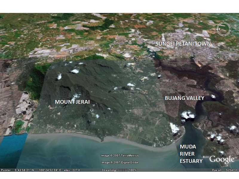
But in fact the town is more than just a would-be suburb of Penang. It is located near the Muda river estuary at the foot of Mount Jerai, which dominates the flat plain that surrounds it. Archeological finds in the Muda river and its tributaries has confirmed the area around Sungei Petani as the site of an ancient Malay port called Kadaram by the Indians and referred to as Ke-da by Chinese Annals.

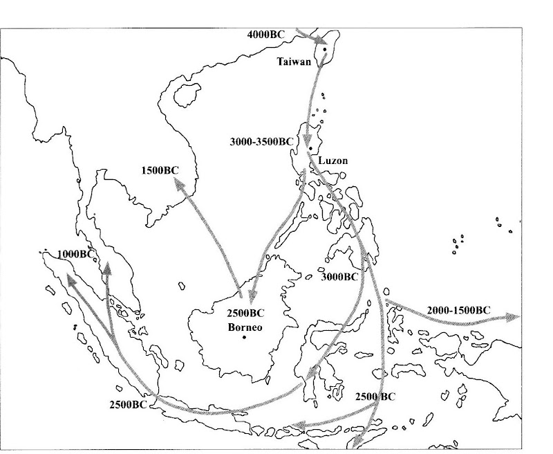
When I was in school 40 years ago, we learned that the early Malays walked down from an area around South China (the area around present day Kunming) following from the proto-Malays. The first and greatest Malay civilization was in Melaka dating from the 14th Century BC. There has been considerable revision since then.

Kedah preceded Melaka by as much as 14 centuries. Several of the archeological finds have been collected, reconstructed and displayed at the Lembah Bujang Archeological Museum on the foothills of Mount Jerai.


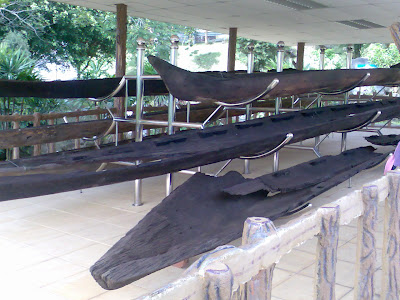
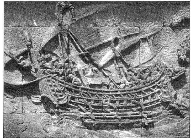
At the entrance of the indoor gallery are what look like dugout canoes, but are believed to have used sails as well. This is the core technology that brought the ancestors of the the Malays from South China to Malaysia by way of the Chang Jiang (the Yangtze River), Taiwan, Phillipines and Borneo. However, the dating of some of these timber boats from the first millenium AD (found on the museum notes) seems a bit incredulous to me!

That is the problem with archaeology in the hot and humid equatorial climate of South East Asia. Timber was the most convenient material for construction, but wood cannot withstand the effects of rot and insect attack. I’ve been told, though, that being submerged in water and in some way deprived of oxygen can preserve some hard-woods.


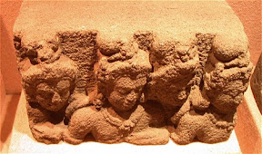
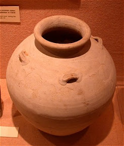
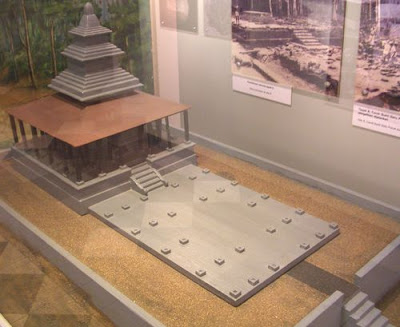
In the indoor gallery are plenty of beads of stones and glass, and ceramic pots that attest to Kedah as a trading port. There are also bits of shrines - some Hindu, some Bhuddist – stone statues, inscriptions in Indian script, granite column base, column sections, clay roof tiles and stone footings for long disintegrated timber posts.


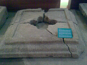
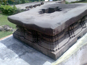
There is an external gallery where the base of some of the ancient shrines have been reconstructed. Some of these were made with granite and local stone, blending in with the stone boulders and outcrops of Mount Jerai. But others used laterite blocks, a softer and courser material.


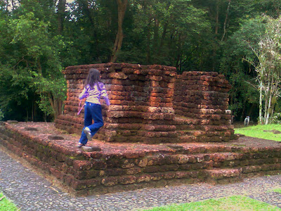
One shrine used clay bricks with detailed corbels and recesses. These were believed to have been imported.


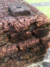
Only the base have been rebuilt, not the columns and the roof. But the stone footings for the timber columns have been put in place and you can just about imagine how these shrines could have looked like.


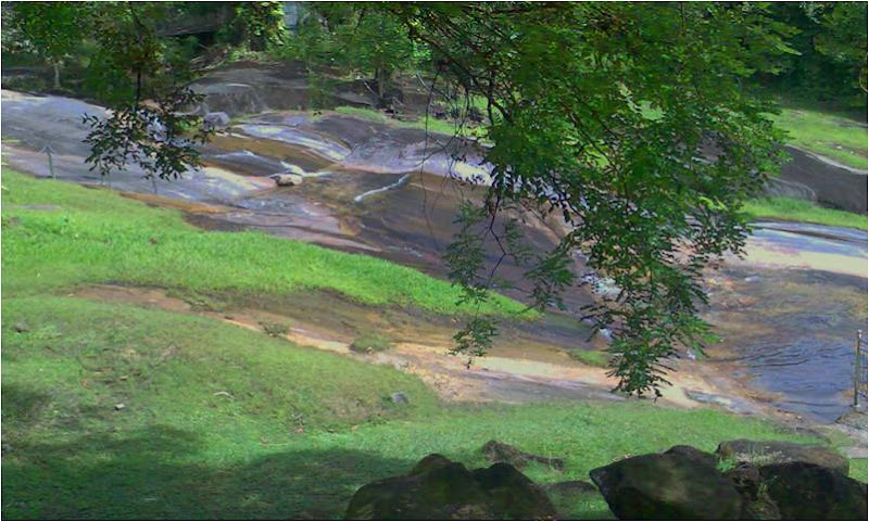
Right next to the museum grounds is a stream that rushes down a stretch of bare stone outcrop. This was where we rested our tired feet. If we had time and energy we could have continued up a trek to the peak of Mount Jerai , but that had to wait until my girls grow up a bit more.


For hotels and other things to do in Kedah, refer to Kedah Hotels

References

George Coedes, "Sriwijaya: History, religion & language of an early Malay polity : collected studies", Monograph of the Malaysian Branch, Royal Asiatic Society.

Related Posts:

Subscribe to Tessellar Blog
and get a FREE E-Book


HONEYCOMB HOUSING
An Affordable Alternative to Terrace Housing


17MB, 49 A4 pages, 57 illustrations


Technorati Tags:,, ,

Friday, December 21, 2007

Kandovan Cave Homes


From Eliza Tasbihi

In the north east of Iran on the border with Azerbaijan is a mountainous province, called…. Azarbayjan. At the foot of Mount Sahand in Kandovan, the villagers live in cave homes carved out from the volcanic rock.


From Eliza Tasbihi

The houses are of two to four storeys; the ground floor is used for animals, the first and maybe second floor as well, are used as living areas, whilst the top floor is used to store things. Most houses face south so residents enjoy sunlight during the day. The houses have windows with decorative glass. It is said that the houses have an “air circulation system that keeps the homes cool in summer and warm in winter”, but I suspect it is the great thermal capacity of the whole mountain rock that is doing the work. Nowadays the houses have electrical connection, water piped in and even waste plumbing.


From Eliza Tasbihi

The Sahand is well known for its spring-water which is believed to be able to cure diseases. A river runs through the valley in the village, providing water for the agricultural terraces and animal husbandry.

The present inhabitants of Kandovan record its history back to the Mongol invasion of Persia in the 13th century when a group of settlers escaped to the village. But the cave village could have existed even before that time. It could be likely...

“given the complex agricultural terracing which covers the steep-sided valleys around the Mount Sahand. Assyrian war annals of the 8th century BC mention towns in the vicinity of Mount Uash (the Assyrian name for Sahand volcano) and these population centres would have required considerable agricultural produce which must have been eked out of the volcanic soil clinging to the slopes of Sahand.”

David Rohl


Back to the present era, People in Kandovan now “mostly live on their income from selling dairy products, meat, wool, honey, handcrafts and dried vegetables”. About 300,000 people visit the village each year.

A relatively recent addition to the village is a 5-star Cliff Hotel dug out from the rock.


From www.skyscrapercity.com


The name Kandovan comes from the old term "Kandou jan". "Kand" means village and "Jan" means existence. As in other places of outstanding beauty and unique features, the way os sustaining a “village existence” looks set to change.

Thanks to Omid, blogging in Persian at www.youngengineer.blogfa.com for telling me about this wonderful village.

Watch a slideshow of Eliza Tasbihi’s photos at Flikr. Highly Recommended!

Watch a video at National Geographic

References:

Related Posts:

Subscribe to Tessellar Blog
and get a FREE E-Book


HONEYCOMB HOUSING
An Affordable Alternative to Terrace Housing


17MB, 49 A4 pages, 57 illustrations


Social Bookmarking

Add to: Digg Add to: Del.icio.us Add to: Reddit Add to: StumbleUpon Add to: Yahoo Add to: Google Add to: Technorati Information